


nismes fourbes oloy

gabelou41
User
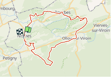

Length
21 km

Max alt
329 m

Uphill gradient
513 m
Km-Effort
27 km

Min alt
137 m

Downhill gradient
512 m
Boucle
Yes
Creation date :
2021-04-24 07:08:49.892
Updated on :
2021-04-24 11:56:58.376
4h47
Difficulty : Very difficult

FREE GPS app for hiking
 SityTrail
IGN / Geographical institutes
SityTrail Plus
The world is yours!
About
Trail Walking of 21 km to be discovered at Wallonia, Namur, Viroinval. This trail is proposed by gabelou41.
Positioning
Country:
Belgium
Region :
Wallonia
Department/Province :
Namur
Municipality :
Viroinval
Location:
Nismes
Start:(Dec)
Start:(UTM)
610791 ; 5547999 (31U) N.
Comments