


69 FRANCHEVILLE par le Châtelard

trietsch
User
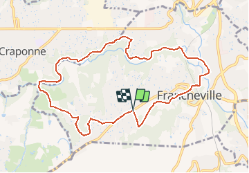

Length
10.6 km

Max alt
313 m

Uphill gradient
214 m
Km-Effort
13.4 km

Min alt
188 m

Downhill gradient
212 m
Boucle
Yes
Creation date :
2021-04-24 12:14:05.729
Updated on :
2021-04-24 12:14:48.81
3h02
Difficulty : Difficult

FREE GPS app for hiking
 SityTrail
IGN / Geographical institutes
SityTrail Plus
The world is yours!
About
Trail Walking of 10.6 km to be discovered at Auvergne-Rhône-Alpes, Métropole de Lyon, Francheville. This trail is proposed by trietsch.
Positioning
Country:
France
Region :
Auvergne-Rhône-Alpes
Department/Province :
Métropole de Lyon
Municipality :
Francheville
Location:
Unknown
Start:(Dec)
Start:(UTM)
636216 ; 5065876 (31T) N.
Comments