


Vercors Plateau du Sornin

c.gourme
User
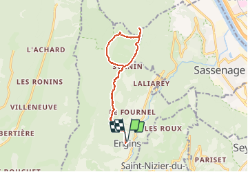

Length
13.5 km

Max alt
1569 m

Uphill gradient
710 m
Km-Effort
23 km

Min alt
924 m

Downhill gradient
714 m
Boucle
Yes
Creation date :
2021-04-24 07:08:48.0
Updated on :
2021-04-24 13:58:29.946
4h58
Difficulty : Medium

FREE GPS app for hiking
 SityTrail
IGN / Geographical institutes
SityTrail Plus
The world is yours!
About
Trail Walking of 13.5 km to be discovered at Auvergne-Rhône-Alpes, Isère, Engins. This trail is proposed by c.gourme.
Positioning
Country:
France
Region :
Auvergne-Rhône-Alpes
Department/Province :
Isère
Municipality :
Engins
Location:
Unknown
Start:(Dec)
Start:(UTM)
705607 ; 5006422 (31T) N.
Comments