


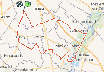
parcours urvillers moy de l'aisne

alainwald
User

Length
21 km

Max alt
120 m

Uphill gradient
180 m
Km-Effort
23 km

Min alt
52 m

Downhill gradient
180 m
Boucle
Yes
Creation date :
2021-04-24 13:12:38.768
Updated on :
2021-04-24 17:08:39.848
3h55
Difficulty : Easy

FREE GPS app for hiking
 SityTrail
IGN / Geographical institutes
SityTrail Plus
The world is yours!
About
Trail Walking of 21 km to be discovered at Hauts-de-France, Aisne, Urvillers. This trail is proposed by alainwald.
Description
entre champs et eaux
Photos


Positioning
Country:
France
Region :
Hauts-de-France
Department/Province :
Aisne
Municipality :
Urvillers
Location:
Unknown
Start:(Dec)
Start:(UTM)
522335 ; 5514284 (31U) N.
Comments