


monthaut

Bwattier
User
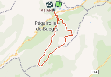

Length
7.8 km

Max alt
648 m

Uphill gradient
480 m
Km-Effort
14.2 km

Min alt
173 m

Downhill gradient
479 m
Boucle
Yes
Creation date :
2021-04-24 08:41:33.599
Updated on :
2021-04-24 20:52:21.167
4h53
Difficulty : Difficult

FREE GPS app for hiking
 SityTrail
IGN / Geographical institutes
SityTrail Plus
The world is yours!
About
Trail Walking of 7.8 km to be discovered at Occitania, Hérault, Pégairolles-de-Buèges. This trail is proposed by Bwattier.
Positioning
Country:
France
Region :
Occitania
Department/Province :
Hérault
Municipality :
Pégairolles-de-Buèges
Location:
Unknown
Start:(Dec)
Start:(UTM)
547563 ; 4851208 (31T) N.
Comments