


11052014

mikaelerouzic
User
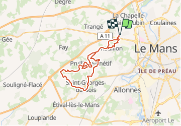

Length
27 km

Max alt
126 m

Uphill gradient
351 m
Km-Effort
32 km

Min alt
56 m

Downhill gradient
351 m
Boucle
Yes
Creation date :
2014-12-10 00:00:00.0
Updated on :
2014-12-10 00:00:00.0
2h25
Difficulty : Difficult

FREE GPS app for hiking
 SityTrail
IGN / Geographical institutes
SityTrail Plus
The world is yours!
About
Trail Running of 27 km to be discovered at Pays de la Loire, Sarthe, Le Mans. This trail is proposed by mikaelerouzic.
Positioning
Country:
France
Region :
Pays de la Loire
Department/Province :
Sarthe
Municipality :
Le Mans
Location:
Unknown
Start:(Dec)
Start:(UTM)
287347 ; 5322393 (31U) N.
Comments