


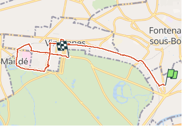
20210425. De Nogent à St Mandé à pied.

hal2012
User

Length
7.4 km

Max alt
69 m

Uphill gradient
39 m
Km-Effort
8 km

Min alt
45 m

Downhill gradient
56 m
Boucle
No
Creation date :
2021-04-25 09:37:25.17
Updated on :
2021-04-25 11:50:56.761
1h43
Difficulty : Easy

FREE GPS app for hiking
 SityTrail
IGN / Geographical institutes
SityTrail Plus
The world is yours!
About
Trail Walking of 7.4 km to be discovered at Ile-de-France, Val-de-Marne, Nogent-sur-Marne. This trail is proposed by hal2012.
Description
Départ 11h40
Retour Bus Château de Vincennes 13h35
Marche 1h37
7.4 km
10500 pas.
Retour en bus 114
Départ 13h40.
Photos


Positioning
Country:
France
Region :
Ile-de-France
Department/Province :
Val-de-Marne
Municipality :
Nogent-sur-Marne
Location:
Unknown
Start:(Dec)
Start:(UTM)
461392 ; 5409561 (31U) N.
Comments