


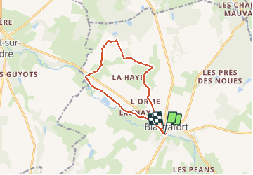
Blancafort 25 04 2021
© OpenStreetMap contributors


2h25
Difficulty : Easy


Length
10.8 km
Max alt
214 m
Uphill gradient
85 m
Km-Effort
12 km
Min alt
163 m
Downhill gradient
85 m
Boucle
Yes
Creation date :
2021-04-25 12:47:46.124
Updated on :
2021-04-25 15:14:07.348
2h25
Difficulty : Easy
FREE GPS app for hiking
 SityTrail
IGN / Geographical institutes
SityTrail Plus
The world is yours!
About
Trail Walking of 10.8 km to be discovered at Centre-Loire Valley, Cher, Blancafort. This trail is proposed by jean.marie.litzler@gmail.com.
Positioning
Country:
France
Region :
Centre-Loire Valley
Department/Province :
Cher
Municipality :
Blancafort
Location:
Unknown
Start:(Dec)
Start:(UTM)
464533 ; 5264260 (31T) N.
Comments