


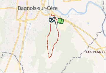
Boucle Berret

ThierryVau
User

Length
4.7 km

Max alt
145 m

Uphill gradient
90 m
Km-Effort
5.9 km

Min alt
50 m

Downhill gradient
92 m
Boucle
Yes
Creation date :
2021-04-26 08:38:24.0
Updated on :
2021-04-26 10:15:54.914
39m
Difficulty : Unknown

FREE GPS app for hiking
 SityTrail
IGN / Geographical institutes
SityTrail Plus
The world is yours!
About
Trail Walking of 4.7 km to be discovered at Occitania, Gard, Bagnols-sur-Cèze. This trail is proposed by ThierryVau.
Description
Boucle zone de Berret / montée de France (Bagnols sur Cèze)
Positioning
Country:
France
Region :
Occitania
Department/Province :
Gard
Municipality :
Bagnols-sur-Cèze
Location:
Unknown
Start:(Dec)
Start:(UTM)
630729 ; 4890075 (31T) N.
Comments