


Monge depuis l'aéroclub de Sisteron

PatriceCocuaud
User
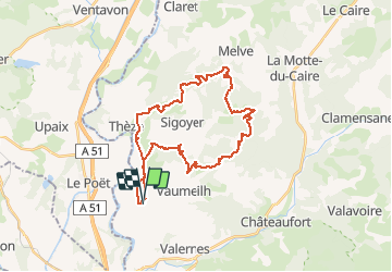

Length
33 km

Max alt
963 m

Uphill gradient
821 m
Km-Effort
44 km

Min alt
519 m

Downhill gradient
821 m
Boucle
Yes
Creation date :
2021-04-26 13:20:43.333
Updated on :
2021-04-26 16:44:25.381
3h14
Difficulty : Medium

FREE GPS app for hiking
 SityTrail
IGN / Geographical institutes
SityTrail Plus
The world is yours!
About
Trail Mountain bike of 33 km to be discovered at Provence-Alpes-Côte d'Azur, Alpes-de-Haute-Provence, Vaumeilh. This trail is proposed by PatriceCocuaud.
Positioning
Country:
France
Region :
Provence-Alpes-Côte d'Azur
Department/Province :
Alpes-de-Haute-Provence
Municipality :
Vaumeilh
Location:
Unknown
Start:(Dec)
Start:(UTM)
734043 ; 4907506 (31T) N.
Comments