


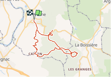
Ariane - Val Crose - Antennes - Capion

ARVIEU
User

Length
18.2 km

Max alt
368 m

Uphill gradient
482 m
Km-Effort
25 km

Min alt
65 m

Downhill gradient
482 m
Boucle
Yes
Creation date :
2021-04-27 16:46:31.361
Updated on :
2021-04-27 16:47:41.164
5h00
Difficulty : Medium

FREE GPS app for hiking
 SityTrail
IGN / Geographical institutes
SityTrail Plus
The world is yours!
About
Trail Walking of 18.2 km to be discovered at Occitania, Hérault, Aniane. This trail is proposed by ARVIEU.
Positioning
Country:
France
Region :
Occitania
Department/Province :
Hérault
Municipality :
Aniane
Location:
Unknown
Start:(Dec)
Start:(UTM)
547262 ; 4836955 (31T) N.
Comments