


Trail étangs

valery cros
User

Length
22 km

Max alt
138 m

Uphill gradient
238 m
Km-Effort
25 km

Min alt
45 m

Downhill gradient
238 m
Boucle
Yes
Creation date :
2021-04-28 09:21:04.0
Updated on :
2021-04-28 09:21:44.788
2h00
Difficulty : Medium

FREE GPS app for hiking
 SityTrail
IGN / Geographical institutes
SityTrail Plus
The world is yours!
About
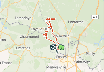
Trail Trail of 22 km to be discovered at Hauts-de-France, Oise, La Chapelle-en-Serval. This trail is proposed by valery cros.
Positioning
Country:
France
Region :
Hauts-de-France
Department/Province :
Oise
Municipality :
La Chapelle-en-Serval
Location:
Unknown
Start:(Dec)
Start:(UTM)
463967 ; 5439115 (31U) N.
Comments