


Nandy 28/04/2021

robinier
User

Length
7.7 km

Max alt
95 m

Uphill gradient
41 m
Km-Effort
8.2 km

Min alt
78 m

Downhill gradient
40 m
Boucle
Yes
Creation date :
2021-04-28 07:00:16.0
Updated on :
2021-04-28 09:28:21.563
2h10
Difficulty : Easy

FREE GPS app for hiking
 SityTrail
IGN / Geographical institutes
SityTrail Plus
The world is yours!
About
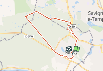
Trail Walking of 7.7 km to be discovered at Ile-de-France, Seine-et-Marne, Nandy. This trail is proposed by robinier.
Positioning
Country:
France
Region :
Ile-de-France
Department/Province :
Seine-et-Marne
Municipality :
Nandy
Location:
Unknown
Start:(Dec)
Start:(UTM)
467921 ; 5380872 (31U) N.
Comments