


Tour 2021de la prairie D'Ambel

junique
User


6h08
Difficulty : Very difficult

FREE GPS app for hiking
 SityTrail
IGN / Geographical institutes
SityTrail Plus
The world is yours!
About
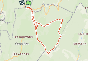
Trail Walking of 18.3 km to be discovered at Auvergne-Rhône-Alpes, Drôme, Omblèze. This trail is proposed by junique.
Description
Parking avant le tunnel du col de la bataille. Passer le col et après, à droite direction pas du gouillat - rapidement a gauche de la piste prendre le sentier qui monte doucement dans la pente - rejoindre le pas du gouillat - puis la tête de la dame en suivant la ligne de crètes - poursuivre vers le pas d'Ambel. Alors prendre à gauche pour atteindre le scialet des quatre gorges - rejoindre le refuge du tubanet - suivre le GR93 vers l'ouest jusqu'a la ferme d'Ambel la ferme d'Ambel puis remonter jusqu'au pas du gouillat - rentrer au col de la bataille par la piste.
Positioning
Comments