


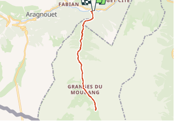
Les Sources de la Reine par les Granges du Moudang

mitch1952
User

Length
14 km

Max alt
1700 m

Uphill gradient
702 m
Km-Effort
23 km

Min alt
1058 m

Downhill gradient
693 m
Boucle
Yes
Creation date :
2021-04-29 09:53:24.912
Updated on :
2022-06-08 13:26:24.906
5h18
Difficulty : Medium

FREE GPS app for hiking
 SityTrail
IGN / Geographical institutes
SityTrail Plus
The world is yours!
About
Trail On foot of 14 km to be discovered at Occitania, Hautespyrenees, Aragnouet. This trail is proposed by mitch1952.
Positioning
Country:
France
Region :
Occitania
Department/Province :
Hautespyrenees
Municipality :
Aragnouet
Location:
Unknown
Start:(Dec)
Start:(UTM)
274813 ; 4740780 (31T) N.
Comments