


Gleyzette Aureville Caulet fait

pidjam
User
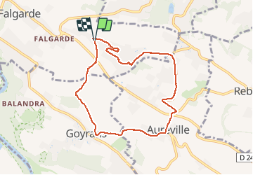

Length
8.4 km

Max alt
261 m

Uphill gradient
216 m
Km-Effort
11.3 km

Min alt
168 m

Downhill gradient
217 m
Boucle
Yes
Creation date :
2021-04-29 11:58:36.631
Updated on :
2021-04-29 14:07:54.406
2h08
Difficulty : Easy

FREE GPS app for hiking
 SityTrail
IGN / Geographical institutes
SityTrail Plus
The world is yours!
About
Trail Walking of 8.4 km to be discovered at Occitania, Haute-Garonne, Lacroix-Falgarde. This trail is proposed by pidjam.
Positioning
Country:
France
Region :
Occitania
Department/Province :
Haute-Garonne
Municipality :
Lacroix-Falgarde
Location:
Unknown
Start:(Dec)
Start:(UTM)
373467 ; 4817301 (31T) N.
Comments