23 km | 32 km-effort
Coo 15,4km
© OpenStreetMap contributors
Walking
--
Difficulty : Unknown
Length
15.4 km
Max alt
502 m
Uphill gradient
566 m
Km-Effort
23 km
Min alt
232 m
Downhill gradient
563 m
Boucle
Yes
Creation date :
2014-12-10 00:00:00.0
Updated on :
2014-12-10 00:00:00.0
--
Difficulty : Unknown
FREE GPS app for hiking
About
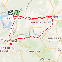
Trail Walking of 15.4 km to be discovered at Wallonia, Liège, Stavelot. This trail is proposed by wandelgidszuidlimburg.
Description
More information on : http://www.wandelgidszuidlimburg.com
Positioning
Country:
Belgium
Region :
Wallonia
Department/Province :
Liège
Municipality :
Stavelot
Location:
Stavelot
Start:(Dec)
Start:(UTM)
704475 ; 5586294 (31U) N.
Comments
Trails nearby
RB-LG-13 - Par monts et par vaux autour de Stoumont
Walking
Very difficult
(11)
Stoumont,
Wallonia,
Liège,
Belgium
7h 19min
Yes
2021-06-30_12h14m27_stavelot_13km_new
Walking
Medium
(2)
Stavelot,
Wallonia,
Liège,
Belgium
13.4 km | 19.8 km-effort
4h 30min
Yes
IR-224 & RB-SoirMag-06_La-Glaise-_QR3_Rac1Rac2_13_9_km
Walking
Medium
(2)
Stoumont,
Wallonia,
Liège,
Belgium
13.9 km | 19.8 km-effort
4h 30min
Yes
2021-03-12_16h39m43_LaGleizeP3TourduMontSaintVictor
Walking
Medium
(2)
Stoumont,
Wallonia,
Liège,
Belgium
15.8 km | 22 km-effort
5h 2min
Yes
2021-03-10_14h59m08_1227
Walking
Difficult
(3)
Stavelot,
Wallonia,
Liège,
Belgium
18.8 km | 26 km-effort
5h 53min
No
Chemin des Sources |stage 3 STAVELOT - HOCKAI
Walking
Very difficult
(1)
Stavelot,
Wallonia,
Liège,
Belgium
19 km | 25 km-effort
5h 45min
No
RB-Lg-13-BC-2019_Rac
Walking
Very difficult
(3)
Stoumont,
Wallonia,
Liège,
Belgium
17.6 km | 24 km-effort
5h 25min
Yes
Extratrail - Stavelot (red) 23km
Trail
Very difficult
(1)
Stavelot,
Wallonia,
Liège,
Belgium
23 km | 35 km-effort
Unknown
Yes
Extra Trail - Stavelot (blue) 13km
Trail
Difficult
(1)
Stavelot,
Wallonia,
Liège,
Belgium
13.4 km | 19.5 km-effort
Unknown
Yes
Superbe rando très vallonnée. ℹ n° 621.