


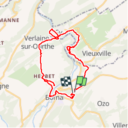
Bomal 15,3km
© OpenStreetMap contributors


--
Difficulty : Unknown


Length
15.3 km
Max alt
252 m
Uphill gradient
426 m
Km-Effort
21 km
Min alt
120 m
Downhill gradient
425 m
Boucle
Yes
Creation date :
2014-12-10 00:00:00.0
Updated on :
2014-12-10 00:00:00.0
--
Difficulty : Unknown
FREE GPS app for hiking
 SityTrail
IGN / Geographical institutes
SityTrail Plus
The world is yours!
About
Trail Walking of 15.3 km to be discovered at Wallonia, Luxembourg, Durbuy. This trail is proposed by wandelgidszuidlimburg.
Description
More information on : http://www.wandelgidszuidlimburg.com


Positioning
Country:
Belgium
Region :
Wallonia
Department/Province :
Luxembourg
Municipality :
Durbuy
Location:
Bomal
Start:(Dec)
Start:(UTM)
680318 ; 5583771 (31U) N.
Comments
42.645
Magnifique parcours, assez ardu mais de toute beauté. 📌 Soit Allée de Pierreuse 8, soit de la gare de Bomal (le parcours passe devant). 📄 Descriptif n° 645