


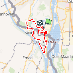
Maastricht 11,6km - 10,3km
© OpenStreetMap contributors


--
Difficulty : Unknown


Length
11.6 km
Max alt
170 m
Uphill gradient
255 m
Km-Effort
14.9 km
Min alt
48 m
Downhill gradient
253 m
Boucle
Yes
Creation date :
2014-12-10 00:00:00.0
Updated on :
2014-12-10 00:00:00.0
--
Difficulty : Unknown
FREE GPS app for hiking
 SityTrail
IGN / Geographical institutes
SityTrail Plus
The world is yours!
About
Trail Walking of 11.6 km to be discovered at Limburg, Unknown, Maastricht. This trail is proposed by wandelgidszuidlimburg.
Description
More information on : http://www.wandelgidszuidlimburg.com


Positioning
Country:
Netherlands
Region :
Limburg
Department/Province :
Unknown
Municipality :
Maastricht
Location:
Unknown
Start:(Dec)
Start:(UTM)
689281 ; 5632944 (31U) N.
Comments
Une randonnée transfrontalière qui monte d'abord au sommet du Sint-Pietersberg, D'n Observant à une altitude de 171 m, avant de passer par l'ancienne ferme Caestert, Petit-Lanaye, la tranchée de Caster, Kanne, le Wijngaardsberg et la grotte du diable. ℹ n° 655.