


Chartreuse Fort Saint Eynard 1000

c.gourme
User
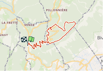

Length
11.8 km

Max alt
1343 m

Uphill gradient
992 m
Km-Effort
25 km

Min alt
769 m

Downhill gradient
990 m
Boucle
Yes
Creation date :
2021-04-30 06:47:28.0
Updated on :
2021-04-30 10:46:59.32
3h40
Difficulty : Medium

FREE GPS app for hiking
 SityTrail
IGN / Geographical institutes
SityTrail Plus
The world is yours!
About
Trail Walking of 11.8 km to be discovered at Auvergne-Rhône-Alpes, Isère, Corenc. This trail is proposed by c.gourme.
Positioning
Country:
France
Region :
Auvergne-Rhône-Alpes
Department/Province :
Isère
Municipality :
Corenc
Location:
Unknown
Start:(Dec)
Start:(UTM)
715899 ; 5012653 (31T) N.
Comments