


Castor et Travignon

Nathy8913
User
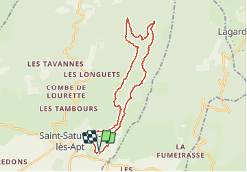

Length
16.5 km

Max alt
969 m

Uphill gradient
776 m
Km-Effort
27 km

Min alt
365 m

Downhill gradient
775 m
Boucle
Yes
Creation date :
2021-04-30 16:43:36.009
Updated on :
2021-04-30 16:43:54.63

FREE GPS app for hiking
 SityTrail
IGN / Geographical institutes
SityTrail Plus
The world is yours!
About
Trail of 16.5 km to be discovered at Provence-Alpes-Côte d'Azur, Vaucluse, Saint-Saturnin-lès-Apt. This trail is proposed by Nathy8913.
Points of interest


Positioning
Country:
France
Region :
Provence-Alpes-Côte d'Azur
Department/Province :
Vaucluse
Municipality :
Saint-Saturnin-lès-Apt
Location:
Unknown
Start:(Dec)
Start:(UTM)
692584 ; 4868029 (31T) N.
Comments