


A Loire

gerardh
User
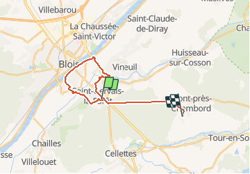

Length
19.8 km

Max alt
108 m

Uphill gradient
162 m
Km-Effort
22 km

Min alt
64 m

Downhill gradient
166 m
Boucle
No
Creation date :
2021-05-02 08:34:08.0
Updated on :
2021-05-02 10:55:00.732
2h21
Difficulty : Very difficult

FREE GPS app for hiking
 SityTrail
IGN / Geographical institutes
SityTrail Plus
The world is yours!
About
Trail Walking of 19.8 km to be discovered at Centre-Loire Valley, Loir-et-Cher, Saint-Gervais-la-Forêt. This trail is proposed by gerardh.
Positioning
Country:
France
Region :
Centre-Loire Valley
Department/Province :
Loir-et-Cher
Municipality :
Saint-Gervais-la-Forêt
Location:
Unknown
Start:(Dec)
Start:(UTM)
377129 ; 5269150 (31T) N.
Comments