


BM-05-1-2021 du 02.05.2021

bene_dictus77
User
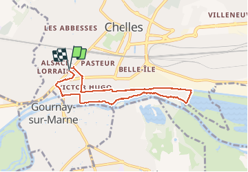

Length
6.5 km

Max alt
45 m

Uphill gradient
32 m
Km-Effort
6.9 km

Min alt
35 m

Downhill gradient
32 m
Boucle
Yes
Creation date :
2021-05-02 09:24:05.542
Updated on :
2021-05-02 11:02:14.212
1h37
Difficulty : Very easy

FREE GPS app for hiking
 SityTrail
IGN / Geographical institutes
SityTrail Plus
The world is yours!
About
Trail Walking of 6.5 km to be discovered at Ile-de-France, Seine-et-Marne, Chelles. This trail is proposed by bene_dictus77.
Description
Jusqu'au lac de Vaires
Positioning
Country:
France
Region :
Ile-de-France
Department/Province :
Seine-et-Marne
Municipality :
Chelles
Location:
Unknown
Start:(Dec)
Start:(UTM)
468999 ; 5413250 (31U) N.
Comments