


CHARTREUSE - Proveysieux - Rocher de l'Eglise

JMHRX2
User
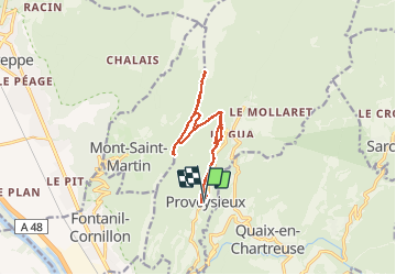

Length
12.4 km

Max alt
1588 m

Uphill gradient
1141 m
Km-Effort
28 km

Min alt
508 m

Downhill gradient
1149 m
Boucle
Yes
Creation date :
2021-04-22 07:48:44.076
Updated on :
2021-05-02 19:01:23.316
5h17
Difficulty : Very difficult

FREE GPS app for hiking
 SityTrail
IGN / Geographical institutes
SityTrail Plus
The world is yours!
About
Trail Walking of 12.4 km to be discovered at Auvergne-Rhône-Alpes, Isère, Proveysieux. This trail is proposed by JMHRX2.
Positioning
Country:
France
Region :
Auvergne-Rhône-Alpes
Department/Province :
Isère
Municipality :
Proveysieux
Location:
Unknown
Start:(Dec)
Start:(UTM)
711695 ; 5015500 (31T) N.
Comments