


Plan-de-la-Tour - 15710 - UtagawaVTT.com

Derrendinger
User
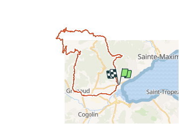

Length
35 km

Max alt
385 m

Uphill gradient
808 m
Km-Effort
46 km

Min alt
0 m

Downhill gradient
807 m
Boucle
Yes
Creation date :
2021-05-02 19:37:56.774
Updated on :
2021-05-02 19:38:23.277
3h11
Difficulty : Very difficult

FREE GPS app for hiking
 SityTrail
IGN / Geographical institutes
SityTrail Plus
The world is yours!
About
Trail Mountain bike of 35 km to be discovered at Provence-Alpes-Côte d'Azur, Var, Grimaud. This trail is proposed by Derrendinger.
Positioning
Country:
France
Region :
Provence-Alpes-Côte d'Azur
Department/Province :
Var
Municipality :
Grimaud
Location:
Unknown
Start:(Dec)
Start:(UTM)
303638 ; 4794809 (32T) N.
Comments