


Erpe-Mere Langs Molenbeek - 12 km RT

wandelroutes
User
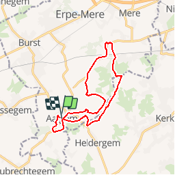

Length
11.8 km

Max alt
53 m

Uphill gradient
109 m
Km-Effort
13.3 km

Min alt
22 m

Downhill gradient
109 m
Boucle
Yes
Creation date :
2014-12-10 00:00:00.0
Updated on :
2014-12-10 00:00:00.0
--
Difficulty : Unknown

FREE GPS app for hiking
 SityTrail
IGN / Geographical institutes
SityTrail Plus
The world is yours!
About
Trail Walking of 11.8 km to be discovered at Flanders, East Flanders, Erpe-Mere. This trail is proposed by wandelroutes.
Description
More information on : http://www.wandelroutes.org


Positioning
Country:
Belgium
Region :
Flanders
Department/Province :
East Flanders
Municipality :
Erpe-Mere
Location:
Aaigem
Start:(Dec)
Start:(UTM)
565872 ; 5637955 (31U) N.
Comments