


SityTrail -

pierre67000
User
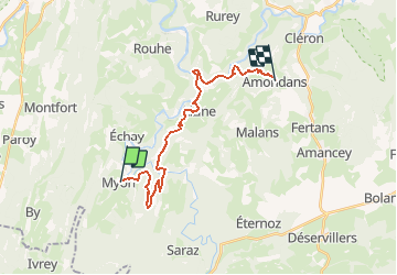

Length
19.3 km

Max alt
509 m

Uphill gradient
677 m
Km-Effort
28 km

Min alt
299 m

Downhill gradient
511 m
Boucle
No
Creation date :
2021-05-04 09:29:14.377
Updated on :
2021-05-04 09:47:29.143
6h18
Difficulty : Very difficult

FREE GPS app for hiking
 SityTrail
IGN / Geographical institutes
SityTrail Plus
The world is yours!
About
Trail Walking of 19.3 km to be discovered at Bourgogne-Franche-Comté, Doubs, Myon. This trail is proposed by pierre67000.
Positioning
Country:
France
Region :
Bourgogne-Franche-Comté
Department/Province :
Doubs
Municipality :
Myon
Location:
Unknown
Start:(Dec)
Start:(UTM)
723691 ; 5212218 (31T) N.
Comments