Trail Horseback riding Lampertsloch - exp_26 Apr 2021 at 17-23-18.gpx - Photo

exp_26 Apr 2021 at 17-23-18.gpx

Promouvoir le Tourisme Equestre en Alsace GUIDE+

© OpenStreetMap contributors
Length
Length
30 km
Max alt
Max alt
358 m
Uphill gradient
Uphill gradient
572 m
Km-Effort
Km-Effort  
38 km
Min alt
Min alt
149 m
Downhill gradient
Downhill gradient
589 m
Boucle
Boucle
Yes
Creation date :
2021-05-04 21:05:50.137
Updated on :
2021-05-04 21:10:27.598

(0 Reviews)

Horseback riding
Horseback riding
4h58
Difficulty : Difficult
Coupling
Coupling
--
Difficulty : Very easy

Scan this QR Code to open this trail in the SityTrail application

FREE GPS app for hiking

Logo SityTrail SityTrail

IGN / Geographical institutes

Download SityTrail from the App Store Download SityTrail from Google Play

Logo SityTrail SityTrail Plus

The world is yours!

Download SityTrail from the App Store Download SityTrail from Google Play Download SityTrail on Huawei AppGallery

About

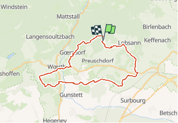
Trail Horseback riding of 30 km to be discovered at Grand Est, Bas-Rhin, Lampertsloch. This trail is proposed by Tourisme Equestre Alsace.

Description

Boucle depuis Lampertsloch adapté aux attelages en passant par Woerth avec le champ de bataille de Woerth, les beaux villages en colombages (Goersdorf, Woerth, Oberdorf-Spachbach et Kutzenhausen) et le premier forage du pétrole du monde (de 1813)

Elevation profile

Photos

Points of interest

Point of interest Gœrsdorf - Chapelle ND du Chene - Photo
Tourisme Equestre Alsace

Positioning

Country:
France
Region :
Grand Est
Department/Province :
Bas-Rhin
Municipality :
Lampertsloch
Location:
Unknown
Start:(UTM)
412823 ; 5424191 (32U) N.


Close
My subscriptions