


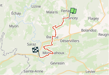
SityTrail - Quingey - Myon

pierre67000
User

Length
17.1 km

Max alt
768 m

Uphill gradient
346 m
Km-Effort
22 km

Min alt
378 m

Downhill gradient
551 m
Boucle
No
Creation date :
2021-05-05 16:10:31.77
Updated on :
2021-05-05 16:39:34.939
4h49
Difficulty : Very difficult

FREE GPS app for hiking
 SityTrail
IGN / Geographical institutes
SityTrail Plus
The world is yours!
About
Trail Walking of 17.1 km to be discovered at Bourgogne-Franche-Comté, Doubs, Amancey. This trail is proposed by pierre67000.
Positioning
Country:
France
Region :
Bourgogne-Franche-Comté
Department/Province :
Doubs
Municipality :
Amancey
Location:
Unknown
Start:(Dec)
Start:(UTM)
277337 ; 5213623 (32T) N.
Comments