


SityTrail -

pierre67000
User
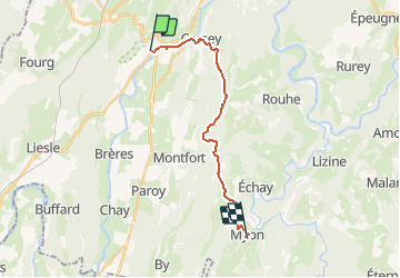

Length
15.8 km

Max alt
545 m

Uphill gradient
420 m
Km-Effort
21 km

Min alt
260 m

Downhill gradient
354 m
Boucle
No
Creation date :
2021-05-05 17:25:06.269
Updated on :
2021-05-05 17:33:04.42
2h11
Difficulty : Medium

FREE GPS app for hiking
 SityTrail
IGN / Geographical institutes
SityTrail Plus
The world is yours!
About
Trail Walking of 15.8 km to be discovered at Bourgogne-Franche-Comté, Doubs, Quingey. This trail is proposed by pierre67000.
Positioning
Country:
France
Region :
Bourgogne-Franche-Comté
Department/Province :
Doubs
Municipality :
Quingey
Location:
Unknown
Start:(Dec)
Start:(UTM)
718730 ; 5220675 (31T) N.
Comments