


Martelange langs de Sure - 7 km RT

wandelroutes
User
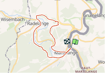

Length
6.9 km

Max alt
475 m

Uphill gradient
204 m
Km-Effort
9.6 km

Min alt
362 m

Downhill gradient
205 m
Boucle
Yes
Creation date :
2014-12-10 00:00:00.0
Updated on :
2014-12-10 00:00:00.0
--
Difficulty : Unknown

FREE GPS app for hiking
 SityTrail
IGN / Geographical institutes
SityTrail Plus
The world is yours!
About
Trail Walking of 6.9 km to be discovered at Unknown, Canton Redange, Rambrouch. This trail is proposed by wandelroutes.
Description
More information on : http://www.wandelroutes.org


Positioning
Country:
Luxembourg
Region :
Unknown
Department/Province :
Canton Redange
Municipality :
Rambrouch
Location:
Unknown
Start:(Dec)
Start:(UTM)
697088 ; 5523671 (31U) N.
Comments