


serre delègue

THIOLIER
User
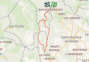

Length
15.2 km

Max alt
1469 m

Uphill gradient
828 m
Km-Effort
26 km

Min alt
840 m

Downhill gradient
829 m
Boucle
Yes
Creation date :
2021-05-06 07:53:26.055
Updated on :
2021-05-06 18:14:04.292
5h43
Difficulty : Very difficult

FREE GPS app for hiking
 SityTrail
IGN / Geographical institutes
SityTrail Plus
The world is yours!
About
Trail Walking of 15.2 km to be discovered at Auvergne-Rhône-Alpes, Drôme, Rochefourchat. This trail is proposed by THIOLIER.
Description
superbes paysages en crête à 360°.
Positioning
Country:
France
Region :
Auvergne-Rhône-Alpes
Department/Province :
Drôme
Municipality :
Rochefourchat
Location:
Unknown
Start:(Dec)
Start:(UTM)
678307 ; 4940761 (31T) N.
Comments