


St Martin d'Abbat EA

AMOURETTE
User
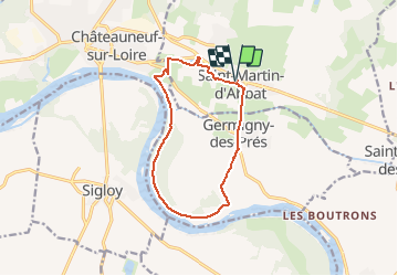

Length
11.5 km

Max alt
128 m

Uphill gradient
79 m
Km-Effort
12.6 km

Min alt
98 m

Downhill gradient
79 m
Boucle
Yes
Creation date :
2021-05-07 10:05:30.661
Updated on :
2021-05-07 10:10:21.307
2h51
Difficulty : Medium

FREE GPS app for hiking
 SityTrail
IGN / Geographical institutes
SityTrail Plus
The world is yours!
About
Trail Walking of 11.5 km to be discovered at Centre-Loire Valley, Loiret, Saint-Martin-d'Abbat. This trail is proposed by AMOURETTE.
Positioning
Country:
France
Region :
Centre-Loire Valley
Department/Province :
Loiret
Municipality :
Saint-Martin-d'Abbat
Location:
Unknown
Start:(Dec)
Start:(UTM)
445061 ; 5300632 (31T) N.
Comments