


07052021 11h M

aderas
User
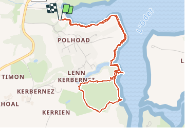

Length
5.9 km

Max alt
29 m

Uphill gradient
55 m
Km-Effort
6.6 km

Min alt
0 m

Downhill gradient
52 m
Boucle
Yes
Creation date :
2021-05-07 09:07:30.915
Updated on :
2021-05-07 10:45:18.657
1h36
Difficulty : Medium

FREE GPS app for hiking
 SityTrail
IGN / Geographical institutes
SityTrail Plus
The world is yours!
About
Trail Walking of 5.9 km to be discovered at Brittany, Finistère, Plomelin. This trail is proposed by aderas.
Positioning
Country:
France
Region :
Brittany
Department/Province :
Finistère
Municipality :
Plomelin
Location:
Unknown
Start:(Dec)
Start:(UTM)
416150 ; 5311589 (30T) N.
Comments