


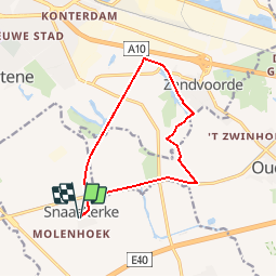
Snaaskerke Oostendse Polders Gistel - 11 km RT

wandelroutes
User

Length
10.8 km

Max alt
5 m

Uphill gradient
36 m
Km-Effort
11.3 km

Min alt
-3 m

Downhill gradient
36 m
Boucle
Yes
Creation date :
2014-12-10 00:00:00.0
Updated on :
2014-12-10 00:00:00.0
--
Difficulty : Unknown

FREE GPS app for hiking
 SityTrail
IGN / Geographical institutes
SityTrail Plus
The world is yours!
About
Trail Walking of 10.8 km to be discovered at Flanders, West Flanders, Gistel. This trail is proposed by wandelroutes.
Description
More information on : http://www.wandelroutes.org


Positioning
Country:
Belgium
Region :
Flanders
Department/Province :
West Flanders
Municipality :
Gistel
Location:
Snaaskerke
Start:(Dec)
Start:(UTM)
495578 ; 5669212 (31U) N.
Comments
