


Mn080521

pe78
User
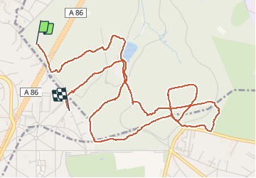

Length
6.7 km

Max alt
177 m

Uphill gradient
134 m
Km-Effort
8.5 km

Min alt
121 m

Downhill gradient
140 m
Boucle
No
Creation date :
2021-05-08 08:21:20.0
Updated on :
2021-05-08 09:55:03.034
1h32
Difficulty : Unknown

FREE GPS app for hiking
 SityTrail
IGN / Geographical institutes
SityTrail Plus
The world is yours!
About
Trail Nordic walking of 6.7 km to be discovered at Ile-de-France, Hauts-de-Seine, Rueil-Malmaison. This trail is proposed by pe78.
Positioning
Country:
France
Region :
Ile-de-France
Department/Province :
Hauts-de-Seine
Municipality :
Rueil-Malmaison
Location:
Unknown
Start:(Dec)
Start:(UTM)
437854 ; 5411721 (31U) N.
Comments