


chemins autour de sorgues

FLORENSAC
User
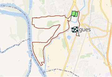

Length
11.2 km

Max alt
32 m

Uphill gradient
77 m
Km-Effort
12.2 km

Min alt
15 m

Downhill gradient
69 m
Boucle
No
Creation date :
2021-05-08 11:35:29.565
Updated on :
2021-05-08 13:17:20.756
1h41
Difficulty : Very easy

FREE GPS app for hiking
 SityTrail
IGN / Geographical institutes
SityTrail Plus
The world is yours!
About
Trail Walking of 11.2 km to be discovered at Provence-Alpes-Côte d'Azur, Vaucluse, Sorgues. This trail is proposed by FLORENSAC.
Description
marche
Positioning
Country:
France
Region :
Provence-Alpes-Côte d'Azur
Department/Province :
Vaucluse
Municipality :
Sorgues
Location:
Unknown
Start:(Dec)
Start:(UTM)
649635 ; 4874683 (31T) N.
Comments