


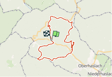
2021-05-08 Marche Nideck Gensbourg

holtzv
User GUIDE

Length
17 km

Max alt
642 m

Uphill gradient
755 m
Km-Effort
27 km

Min alt
298 m

Downhill gradient
756 m
Boucle
Yes
Creation date :
2021-05-08 08:05:05.144
Updated on :
2021-05-08 14:49:22.166
4h30
Difficulty : Very difficult

FREE GPS app for hiking
 SityTrail
IGN / Geographical institutes
SityTrail Plus
The world is yours!
About
Trail Walking of 17 km to be discovered at Grand Est, Bas-Rhin, Oberhaslach. This trail is proposed by holtzv.
Positioning
Country:
France
Region :
Grand Est
Department/Province :
Bas-Rhin
Municipality :
Oberhaslach
Location:
Unknown
Start:(Dec)
Start:(UTM)
373617 ; 5380946 (32U) N.
Comments