


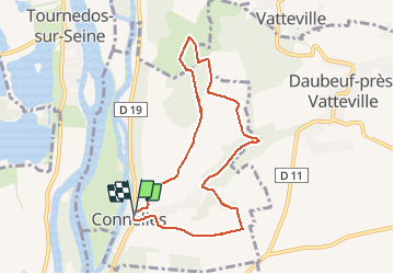
20210508 Connelles

Childebert
User

Length
7.6 km

Max alt
130 m

Uphill gradient
176 m
Km-Effort
10 km

Min alt
11 m

Downhill gradient
177 m
Boucle
Yes
Creation date :
2021-05-08 12:17:51.33
Updated on :
2021-05-08 16:54:05.852
2h14
Difficulty : Medium

FREE GPS app for hiking
 SityTrail
IGN / Geographical institutes
SityTrail Plus
The world is yours!
About
Trail Walking of 7.6 km to be discovered at Normandy, Eure, Connelles. This trail is proposed by Childebert.
Positioning
Country:
France
Region :
Normandy
Department/Province :
Eure
Municipality :
Connelles
Location:
Unknown
Start:(Dec)
Start:(UTM)
374151 ; 5457308 (31U) N.
Comments