


St hipollyte bonnay

mcterret
User
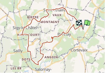

Length
22 km

Max alt
410 m

Uphill gradient
435 m
Km-Effort
28 km

Min alt
212 m

Downhill gradient
434 m
Boucle
Yes
Creation date :
2021-05-08 07:48:54.58
Updated on :
2021-05-08 15:26:33.528
6h37
Difficulty : Medium

FREE GPS app for hiking
 SityTrail
IGN / Geographical institutes
SityTrail Plus
The world is yours!
About
Trail Walking of 22 km to be discovered at Bourgogne-Franche-Comté, Saône-et-Loire, Bonnay. This trail is proposed by mcterret.
Positioning
Country:
France
Region :
Bourgogne-Franche-Comté
Department/Province :
Saône-et-Loire
Municipality :
Bonnay
Location:
Unknown
Start:(Dec)
Start:(UTM)
625990 ; 5156797 (31T) N.
Comments
tu