Trail Nordic walking Favières - Le Crotoy  - Photo
© OpenStreetMap contributors
Length
Length
15.4 km
Max alt
Max alt
13 m
Uphill gradient
Uphill gradient
65 m
Km-Effort
Km-Effort  
16.3 km
Min alt
Min alt
0 m
Downhill gradient
Downhill gradient
66 m
Boucle
Boucle
Yes
Creation date :
2021-05-09 06:49:36.0
Updated on :
2021-05-09 16:54:39.367

(0 Reviews)

Nordic walking
Nordic walking
3h31
Difficulty : Unknown

Scan this QR Code to open this trail in the SityTrail application

FREE GPS app for hiking

Logo SityTrail SityTrail

IGN / Geographical institutes

Download SityTrail from the App Store Download SityTrail from Google Play

Logo SityTrail SityTrail World

The world is yours!

Download SityTrail from the App Store Download SityTrail from Google Play Download SityTrail on Huawei AppGallery

About

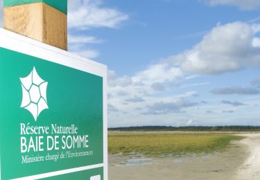
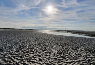
Trail Nordic walking of 15.4 km to be discovered at Hauts-de-France, Somme, Favières. This trail is proposed by roselinemazeyrat.

Description

Ne pas faire en période de chasse parce que le bois est fermé. Idéalement, partir environ 2h avant la haute mer, pour voir arriver le flot au retour. Le parcours permet d'arriver à pied sec.

Elevation profile

Photos

Positioning

Country:
France
Region :
Hauts-de-France
Department/Province :
Somme
Municipality :
Favières
Location:
Unknown
Start:(UTM)
404007 ; 5563503 (31U) N.

Trails nearby

Trail Walking Saint-Valery-sur-Somme - Balade à Saint-Valéry-sur-Somme - Photo
Walking
GUIDE
Desrumaux

Walking

Easy
(4)
Saint-Valery-sur-Somme, Hauts-de-France, Somme, France
10.4 km | 12.2 km-effort
2h 41min
Yes
Trail Walking Le Crotoy - CDT80-3 - Photo
Walking

Walking

Medium
(2)
Le Crotoy, Hauts-de-France, Somme, France
6 km | 6.1 km-effort
1h 23min
Yes
Trail Walking Saint-Valery-sur-Somme - Balade à Saint-Valery sur Somme - Photo
Walking
tracegps

Walking

Medium
(3)
Saint-Valery-sur-Somme, Hauts-de-France, Somme, France
7.1 km | 8.6 km-effort
2h 19min
Yes
Trail Walking Favières - Circuit de Morlay - Photo
Walking
tracegps

Walking

Difficult
(1)
Favières, Hauts-de-France, Somme, France
12.4 km | 12.8 km-effort
4h 0min
Yes
Trail Walking Saint-Valery-sur-Somme - Traversée Baie de Somme 11/08/2021 - Photo
Walking
GUIDE
R@ph

Walking

Medium
Saint-Valery-sur-Somme, Hauts-de-France, Somme, France
8.5 km | 8.8 km-effort
2h 0min
No
Trail Walking Saint-Valery-sur-Somme - w-frankrijk-over-dijken-en-kwelders - Photo
Walking
gpstracks

Walking

Very easy
(2)
Saint-Valery-sur-Somme, Hauts-de-France, Somme, France
13.8 km | 14.9 km-effort
Unknown
Yes
Trail Mountain bike Saint-Valery-sur-Somme - Gravelot Baie de sommes - Photo
Mountain bike
Jeanlouisbray

Mountain bike

Easy
(1)
Saint-Valery-sur-Somme, Hauts-de-France, Somme, France
44 km | 47 km-effort
4h 56min
Yes
Trail Equestrian Le Crotoy - de la Maye vers marquenterre - Photo
Equestrian
ioudina

Equestrian

Very easy
(4)
Le Crotoy, Hauts-de-France, Somme, France
20 km | 21 km-effort
2h 43min
No
Trail Cycle Le Crotoy - Crotoy - Marquenterre - Photo
Cycle
jacques.moulin@hotmail.com

Cycle

Medium
(1)
Le Crotoy, Hauts-de-France, Somme, France
18.3 km | 19.2 km-effort
1h 8min
Yes


Close
My subscriptions