


05-2-2021 du 9.05.2021

bene_dictus77
User

Length
11.4 km

Max alt
68 m

Uphill gradient
66 m
Km-Effort
12.3 km

Min alt
34 m

Downhill gradient
82 m
Boucle
No
Creation date :
2021-05-09 08:20:30.436
Updated on :
2021-05-09 11:31:32.734
3h10
Difficulty : Very easy

FREE GPS app for hiking
 SityTrail
IGN / Geographical institutes
SityTrail Plus
The world is yours!
About
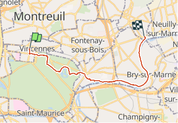
Trail Walking of 11.4 km to be discovered at Ile-de-France, Val-de-Marne, Vincennes. This trail is proposed by bene_dictus77.
Description
du château de Vincennes à Neuilly Plaisance Rer
Positioning
Country:
France
Region :
Ile-de-France
Department/Province :
Val-de-Marne
Municipality :
Vincennes
Location:
Unknown
Start:(Dec)
Start:(UTM)
458521 ; 5410634 (31U) N.
Comments