


Pic des mouches - Citadelle de Vauvenargues

georgein
User

Length
13.5 km

Max alt
236 m

Uphill gradient
432 m
Km-Effort
19.2 km

Min alt
57 m

Downhill gradient
430 m
Boucle
Yes
Creation date :
2021-05-09 09:18:27.95
Updated on :
2021-08-10 08:26:13.096
4h03
Difficulty : Difficult

FREE GPS app for hiking
 SityTrail
IGN / Geographical institutes
SityTrail Plus
The world is yours!
About
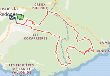
Trail Walking of 13.5 km to be discovered at Provence-Alpes-Côte d'Azur, Bouches-du-Rhône, Ensuès-la-Redonne. This trail is proposed by georgein.
Positioning
Country:
France
Region :
Provence-Alpes-Côte d'Azur
Department/Province :
Bouches-du-Rhône
Municipality :
Ensuès-la-Redonne
Location:
Unknown
Start:(Dec)
Start:(UTM)
678957 ; 4802111 (31T) N.
Comments