


jonchée.cretes de praloubiau

Joel26400
User
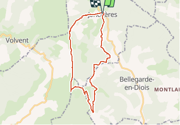

Length
16.1 km

Max alt
1514 m

Uphill gradient
749 m
Km-Effort
26 km

Min alt
893 m

Downhill gradient
748 m
Boucle
Yes
Creation date :
2021-05-09 07:14:01.697
Updated on :
2021-05-09 14:23:54.898
4h55
Difficulty : Medium

FREE GPS app for hiking
 SityTrail
IGN / Geographical institutes
SityTrail Plus
The world is yours!
About
Trail Walking of 16.1 km to be discovered at Auvergne-Rhône-Alpes, Drôme, Jonchères. This trail is proposed by Joel26400.
Description
belle crêtes
Positioning
Country:
France
Region :
Auvergne-Rhône-Alpes
Department/Province :
Drôme
Municipality :
Jonchères
Location:
Unknown
Start:(Dec)
Start:(UTM)
690884 ; 4938181 (31T) N.
Comments