


regain circuit

elcanario
User
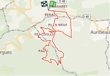

Length
12.5 km

Max alt
861 m

Uphill gradient
480 m
Km-Effort
18.9 km

Min alt
539 m

Downhill gradient
480 m
Boucle
Yes
Creation date :
2021-05-09 08:31:44.306
Updated on :
2021-05-09 14:46:19.106
6h14
Difficulty : Medium

FREE GPS app for hiking
 SityTrail
IGN / Geographical institutes
SityTrail Plus
The world is yours!
About
Trail Walking of 12.5 km to be discovered at Provence-Alpes-Côte d'Azur, Vaucluse, Saignon. This trail is proposed by elcanario.
Positioning
Country:
France
Region :
Provence-Alpes-Côte d'Azur
Department/Province :
Vaucluse
Municipality :
Saignon
Location:
Unknown
Start:(Dec)
Start:(UTM)
695350 ; 4857556 (31T) N.
Comments