


L'hospitalet La clape

Ada11
User GUIDE
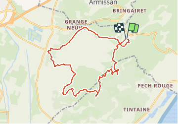

Length
21 km

Max alt
201 m

Uphill gradient
502 m
Km-Effort
27 km

Min alt
13 m

Downhill gradient
504 m
Boucle
Yes
Creation date :
2021-05-09 06:56:20.0
Updated on :
2021-05-09 15:05:32.258
5h00
Difficulty : Easy

FREE GPS app for hiking
 SityTrail
IGN / Geographical institutes
SityTrail Plus
The world is yours!
About
Trail Walking of 21 km to be discovered at Occitania, Aude, Narbonne. This trail is proposed by Ada11.
Photos


Positioning
Country:
France
Region :
Occitania
Department/Province :
Aude
Municipality :
Narbonne
Location:
Unknown
Start:(Dec)
Start:(UTM)
509254 ; 4779400 (31T) N.
Comments