


20190111 Aigues champs

RobinMicheline
User GUIDE
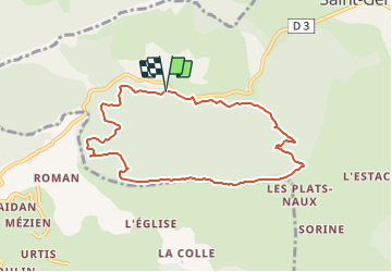

Length
8.4 km

Max alt
1295 m

Uphill gradient
317 m
Km-Effort
12.7 km

Min alt
1032 m

Downhill gradient
323 m
Boucle
Yes
Creation date :
2021-05-10 20:29:55.182
Updated on :
2021-05-31 13:42:01.743
2h52
Difficulty : Easy

FREE GPS app for hiking
 SityTrail
IGN / Geographical institutes
SityTrail Plus
The world is yours!
About
Trail On foot of 8.4 km to be discovered at Provence-Alpes-Côte d'Azur, Alpes-de-Haute-Provence, Saint-Geniez. This trail is proposed by RobinMicheline.
Positioning
Country:
France
Region :
Provence-Alpes-Côte d'Azur
Department/Province :
Alpes-de-Haute-Provence
Municipality :
Saint-Geniez
Location:
Unknown
Start:(Dec)
Start:(UTM)
262117 ; 4902264 (32T) N.
Comments