


vlf 2021-05-11 Desnie

maleclere
User
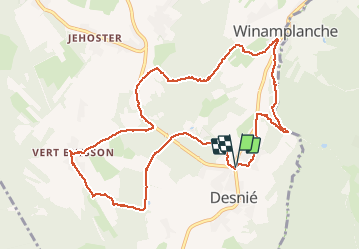

Length
10.6 km

Max alt
457 m

Uphill gradient
253 m
Km-Effort
13.9 km

Min alt
255 m

Downhill gradient
255 m
Boucle
Yes
Creation date :
2021-05-11 07:36:07.3
Updated on :
2021-05-11 12:17:39.823
2h39
Difficulty : Medium

FREE GPS app for hiking
 SityTrail
IGN / Geographical institutes
SityTrail Plus
The world is yours!
About
Trail Walking of 10.6 km to be discovered at Wallonia, Liège, Theux. This trail is proposed by maleclere.
Positioning
Country:
Belgium
Region :
Wallonia
Department/Province :
Liège
Municipality :
Theux
Location:
La Reid
Start:(Dec)
Start:(UTM)
699508 ; 5593805 (31U) N.
Comments