


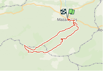
Barres de Mazaugues

BerFran
User

Length
18.7 km

Max alt
911 m

Uphill gradient
674 m
Km-Effort
28 km

Min alt
408 m

Downhill gradient
675 m
Boucle
Yes
Creation date :
2021-05-12 06:51:44.0
Updated on :
2021-05-14 17:13:05.555
5h00
Difficulty : Medium

FREE GPS app for hiking
 SityTrail
IGN / Geographical institutes
SityTrail Plus
The world is yours!
About
Trail Walking of 18.7 km to be discovered at Provence-Alpes-Côte d'Azur, Var, Mazaugues. This trail is proposed by BerFran.
Photos


Positioning
Country:
France
Region :
Provence-Alpes-Côte d'Azur
Department/Province :
Var
Municipality :
Mazaugues
Location:
Unknown
Start:(Dec)
Start:(UTM)
736847 ; 4803650 (31T) N.
Comments