


SAINT JACQUES. PRE DE SIROM . ENTRE PUY , PIED MARCELLIN . Chateau plus haut , Chaudon , col de Chaudon ,

RobinMicheline
User GUIDE
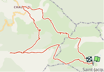

Length
16.5 km

Max alt
1224 m

Uphill gradient
659 m
Km-Effort
25 km

Min alt
862 m

Downhill gradient
660 m
Boucle
Yes
Creation date :
2021-05-13 05:59:52.234
Updated on :
2021-05-13 15:48:34.083
4h52
Difficulty : Difficult

FREE GPS app for hiking
 SityTrail
IGN / Geographical institutes
SityTrail Plus
The world is yours!
About
Trail Walking of 16.5 km to be discovered at Provence-Alpes-Côte d'Azur, Alpes-de-Haute-Provence, Saint-Jacques. This trail is proposed by RobinMicheline.
Description
Belle rando
Petits sentiers sympas, Beaux paysages
Photos


Positioning
Country:
France
Region :
Provence-Alpes-Côte d'Azur
Department/Province :
Alpes-de-Haute-Provence
Municipality :
Saint-Jacques
Location:
Unknown
Start:(Dec)
Start:(UTM)
289398 ; 4871952 (32T) N.
Comments